
A Novel Geoengineering Strategy to Combat Sea Level Rise (1)
/In the ongoing debate over what to do, if anything, about rising global temperatures, adaptation has so far played second fiddle to mitigation. Grandiose geoengineering proposals to reflect the sun’s rays by injecting aerosols into the stratosphere or placing giant reflectors in orbit have been largely dismissed because of the unknown risks and possible unintended consequences of such moves.
But now a new geoengineering strategy with relatively benign and even beneficial consequences has been proposed by Russ Walsh, a California cybersecurity engineer: moving water from the world’s oceans to arid regions like Australia and the Sahara, in order to combat sea level rise.
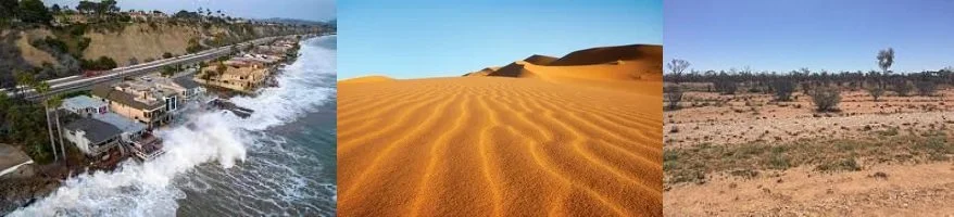
Rising sea levels is a controversial topic. While there’s no doubt that the average global sea level has been increasing ever since the world started to warm after the Little Ice Age ended around 1850, no reliable scientific evidence exists that the rate of rise is currently accelerating over time, as is sometimes claimed. Nevertheless, the average sea level is currently going up at about 4.3 mm per year, according to NASA. If that continues for the next 50 years, the rise will be 21.5 cm (8.5 inches) – enough to cause serious problems and flooding in low-lying coastal areas.
Although extracting seawater from the oceans will be a massive and difficult project, it would avoid the problems of encroaching seas and the need to build seawalls all across the globe, or to eventually relocate nearly a third of the world’s population and infrastructure to higher ground.
The project would comprise four or five major components: pumping seawater from the ocean; possible desalination; transporting the water to its destination via waterways or canals; excavation of inland lakes to hold the water; and finishing work such as creation of surrounding hills or coastal protection with excavated earth.
Walsh is a visionary undaunted by the technical challenges of such an undertaking. With decades of experience working with major corporations, he is well connected with the types of companies his fledgling venture would need to work with to realize his vision. And he has bounced his concept off several of these companies, as well as water management experts and Stanford University engineering professors, all of whom have found it promising.
The concept is illustrated in the figure below, which shows schematically what the first phases of the project would entail. Built on an extended stretch of relatively flat, arid and mostly uninhabited land along the coastline, small test ponds and mini-lakes, ranging in surface area from 150 by 150 meters (500 by 500 feet) to 1.6 by 1.6 km (1 by 1 miles), would be connected to the nearby ocean via a dredged canal.
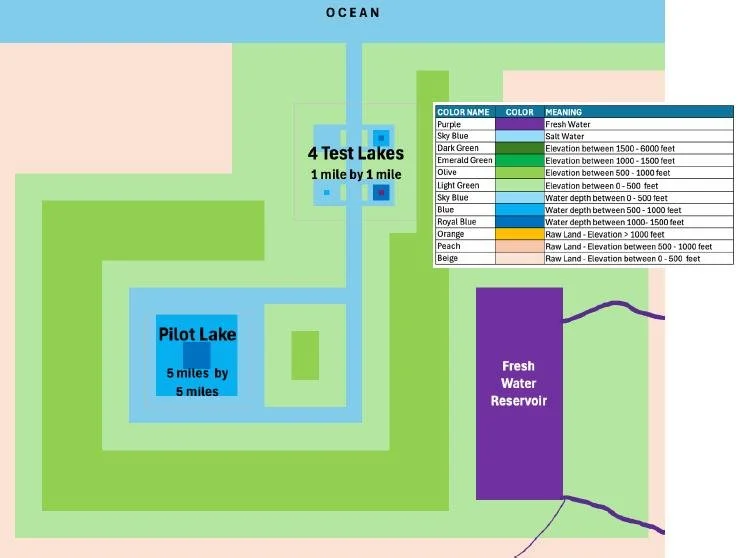
COPYRIGHT © RUSS WALSH
The next step would be excavation of a larger pilot lake, with a surface area of perhaps 8 by 8 km (5 by 5 miles), connected to the smaller lakes by the same canal. All lakes would of course have sloping sides, the exact slope determined by the local soil type and the need to avoid landslides. As indicated in the figure, pilot lakes could be as deep as 460 meters (1,500 feet) at their centers.
The following figure shows the next phase of proposed development, involving excavation of much larger “basic lakes,” now 56 by 56 km (35 by 35 miles) in surface area and with depths up to 760 meters (2,500 feet); a second canal would probably be required to help fill such large lakes. The enormous volumes of excavated earth could be used to create artificial hills in the region surrounding the lakes or to protect the coastline from erosion.

COPYRIGHT © RUSS WALSH
The lakes shown would all contain seawater, although a desalination plant could if necessary be placed near where the canals enter the ocean. The freshwater reservoir depicted in the first schematic figure above is an option, constructed on a nearby river which perhaps wends its way to the ocean through an existing town or seaport. If the river is large enough, the freshwater could be used to fill one of the planned basic lakes. Freshwater would be needed for any future residents of the lake area or for future farms in the same region.
Walsh in fact envisages the area surrounding the lakes as a kind of newly created oasis, a thriving transformed region drawing millions of residents and tourists. Many of the new arrivals might even live on the lakes themselves, in houseboats or possibly cruise ships. Even the initial pilot lake region would actually be about the size of the Las Vegas valley in Nevada, which is currently home to approximately 3 million people.
In the second part of this post, I’ll discuss further scaling up of this revolutionary concept, together with some of the engineering challenges and hopes of bringing the concept to fruition.
Next: A Novel Geoengineering Strategy to Combat Sea Level Rise (2)


